A super El Niño due this year and the world is not ready

The numbers released last week by an international consortium of climate scientists are remarkable in their uniformity. Every single key indicator of the state of the Earth's climate system set a new record in 2025. And not in a good way.
Ocean heating. Greenhouse gas concentrations. The pace of human-induced warming. The number of days experiencing marine heatwaves. The Earth's Energy Imbalance (EEI) — the difference between heat arriving from the sun and heat escaping back into space. All of them reached levels never previously recorded in the instrumental history of the planet.
The The Climate Crisis is accelerating. The IPCC says that the Paris Agreement goal of keeping temperature increases to less than 1.5°C-2°C above the pre-industrial benchmark has already been missed and temperature increase are on course to reach a catastrophic 2.7C-3.1C by 2050.
And now, belatedly, the smashed records are having an impact on policymakers. Now a new signal is emerging from the Pacific Ocean that threatens to amplify everything and will force policy makers to recalibrate again. And quickly. An El Niño of potentially historic proportions is on its way that is leading scientists say this could be the most powerful in all the 140 years of observation.
The collision of these two phenomena — a climate system already running hotter than at any point in recorded history, and a cyclical weather event that adds further heat on top — is what makes the next eighteen months a period of unusual concern for climate scientists, agricultural economists and commodity markets simultaneously.
Every record broken
The fourth annual "Indicators of Global Climate Change" report, published on April 23 by a consortium of more than 50 researchers from institutions including Oxford, Imperial College London, NOAA, the Met Office, ETH Zurich and the Chinese Academy of Sciences, tracks twelve key sets of climate indicators using methods closely aligned with the Intergovernmental Panel on Climate Change's (IPCC) Sixth Assessment Report.
Human-induced warming reached 1.37°C above pre-industrial levels in 2025, increasing at a rate of 0.27°C per decade over the 2016-2025 period — a pace that matches the all-time high seen in the previous year's record. This was caused by a combination of greenhouse gas emissions being at an all-time high of 54.6 gigatonnes of CO₂ equivalent per year over the 2015-2024 decade, as well as reductions in the cooling effect of aerosols.
The Earth's energy imbalance — the most fundamental measure of the pace of climate change — has more than doubled since the 1976-1995 period. The number of days experiencing marine heatwaves has more than tripled between 1991 and 2025. Ocean heating, the report notes, is literally off the charts — running beyond the range that prior scientific publications had projected.
The report carries a warning that goes beyond the climate data itself. The scientific datasets underpinning these indicators are under threat from the Trump administration cuts to climate related research. US President Donald Trump, a climate change denier, is systematically undermining the scientific institutions that are studying and advising on countering the impact of the Climate Crisis. Funding for key satellite and in-situ observing programmes critical for monitoring the atmosphere, ocean, cryosphere and land surface has been cancelled in a head-in-the-sand policy decision.
The Global Climate Observing System framework, which supports much of the international monitoring capability, is described as "under threat." The ability to monitor many of the indicators presented may not be guaranteed without concerted international action. The reference to public funding cuts is widely understood as a pointed commentary on the Trump administration's dismantling of NOAA's climate research programmes.
Super El Niño
Into this already supercharged climate system, a devastating “super El Niño” is developing.
What is a super El Niño and why is that a problem? What does it do?
El Niño is the warm phase of the El Niño-Southern Oscillation cycle — a periodic warming of surface waters across the central and eastern tropical Pacific that reshapes weather patterns across the entire planet.
In a normal year, trade winds push warm water westward, keeping the eastern Pacific relatively cool. When those winds weaken or reverse, the warm water sloshes back east, releasing vast quantities of heat into the atmosphere. The consequences ripple outward in all directions: droughts in Australia, India, South-East Asia and southern Africa; flooding in South America and the southern United States; disruption to the Asian monsoon; suppressed Atlantic hurricane activity; and a global spike in temperatures that adds on top of whatever the background warming trend already is.
A strong El Niño is economically significant. A super El Niño — one that pushes Pacific sea surface temperatures more than 2°C above the seasonal average — is a different order of problem entirely. The 1997-98 super El Niño is estimated to have caused between $4.1 and $5.7 trillion in global economic damage, according to a 2023 analysis, affecting agricultural output on every inhabited continent, triggering catastrophic flooding and wildfires simultaneously, and driving the single largest annual spike in global temperatures ever recorded at that time. The 2015-16 event produced similar disruption. Both arrived into a planet that was cooler than today. A super El Niño landing on a climate system that is already running at record heat — as every indicator confirms it now is — would have no historical precedent from which to extrapolate its consequences.
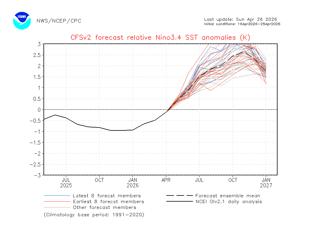
NOAA's Climate Prediction Center currently places a 61% probability on El Niño conditions emerging by May-July 2026 and persisting through at least the end of the year. The agency places a 25% — one in four — chance of the event reaching "very strong" status, with Niño 3.4 anomalies exceeding +2.0°C. ENSO-neutral conditions are expected to persist through April-June before the transition.
Those are the official figures. The modelling community is, in some cases, going considerably further. The European Centre for Medium-Range Weather Forecasts April 2026 ensemble forecast shows individual anomaly projections for the Niño 3.4 region ranging from approximately 1.7°C to 3.3°C by September — with roughly half of the ensemble calling for sea surface temperatures to exceed 2.5°C above the seasonal average by October, territory that would correspond to what is loosely described as a "super El Niño."
Carbon Brief estimates that the latest climate models provide a median forecast of 2.2°C warming in the Niño 3.4 region by September — firmly in "super El Niño" territory — with warming expected to build further after September, since El Niño conditions generally peak between November and January.
The historical context for these projections is sobering. Since 1950, only five El Niño events have reached the "super" threshold of at least +2.0°C for at least one three-month interval: 1972-73, 1982-83, 1997-98, 2015-16, and 2023-24. Only the 2015-16 event pushed past +2.5°C.
ENSO expert Paul Roundy of the University at Albany notes that the anomalous westerly winds over the western tropical Pacific are currently exerting more force than those recorded during spring 1997 — the embryonic stages of the super El Niño of 1997-98 that caused an estimated $4.1 to $5.7 trillion in global economic damage according to a 2023 analysis. Roundy assesses there is "real potential for the strongest El Niño event in 140 years."
The IPCC”s CFSv2 model, which is among the most widely tracked forecasting tools, is now projecting peak anomalies of between +2.63°C and +3.48°C by November 2026 — levels that would exceed any event in the observational record.
Why this one is different
Every El Niño adds heat on top of background temperatures. But background temperatures are no longer static. Carbon Brief estimates that global average temperature in 2026 will fall between 1.37°C and 1.58°C above pre-industrial levels, with a best estimate of 1.47°C — virtually certain to make 2026 one of the four warmest years on record, with a 19% chance it beats 2024 as the outright warmest. If a super El Niño peaks in late 2026 and early 2027, the 2027 global temperature record would be at serious risk.
The spring "predictability barrier" — the well-documented tendency of El Niño forecasts made before April to prove unreliable — is being watched closely. Climate modellers note that this year's signal is unusual: rather than fading as the barrier approaches, as often happens, the forecasts are strengthening. The ECMWF ensemble range has tightened notably since January, and the intensity has increased — a pattern that scientists say reflects genuine underlying physical conditions rather than model artefacts.
The economic consequences of a super El Niño landing on an already stressed global food system are the source of most concern among commodity analysts and agricultural economists. And a food shock is already anticipated by the collapse of fertilises from the Gulf as a result of America’s war there.
India faces the most acute near-term risk. El Niño events are strongly associated with monsoon volatility in South Asia — reduced rainfall, prolonged dry spells and intense heatwaves that drive crop stress. India is the world's most populous country, a major exporter of rice and wheat, and already dealing with elevated food inflation. Japan's meteorological agency has placed a 70% probability on El Niño conditions forming by summer, with forecasters flagging risks extending across Asia including reduced output in China and South and South-East Asia.
The timing could hardly be worse. The fertiliser shock from the Iran war has already pushed urea prices above $700 per metric ton — up more than 50% since the conflict began — and depleted agricultural input stocks across South Asia and Africa. El Niño-driven yield reductions stacking on top of fertiliser-driven yield reductions would represent a compounding shock to global food supply that agricultural economists describe as a perfect storm.
Sugar is historically among the most El Niño-sensitive crops, with Brazilian and Indian production particularly exposed. Grains follow closely, with Australia — typically a major wheat exporter — facing drier conditions on El Niño years. Palm oil production in Indonesia and Malaysia, which together account for approximately 85% of global supply, is also strongly negatively correlated with El Niño intensity.
For energy markets, the dynamics cut in multiple directions. El Niño-driven heatwaves in Asia boost electricity demand dramatically, stressing power grids already under pressure. Reduced hydropower generation — a significant factor in China, Brazil, India and parts of South-East Asia — pushes up gas and coal demand. At the same time, reduced wind and solar irradiance in affected regions can dampen renewable generation. All of this arrives into a global energy system already dealing with the disruption to Gulf LNG and oil supplies from the Iran war.
The monitoring crisis
One dimension of the El Niño story that has received almost no attention outside specialist circles is the deterioration in the monitoring infrastructure needed to track it. The Indicators of Global Climate Change report's warning about threats to observing programmes is not hypothetical. NOAA, which operates the critical network of Argo floats, buoys and satellites that underpin El Niño forecasting, has seen significant funding and staffing cuts in 2025-26. Several long-running Pacific observation buoy arrays have reduced reporting frequencies. The irony of facing potentially the most powerful El Niño in recorded history while simultaneously degrading the monitoring systems needed to track it has not been lost on the scientific community.
"We are flying increasingly blind into an event that could be the most consequential climate driver of the decade," one senior climate scientist said, declining to be named given sensitivities around public funding. "The models are telling us something very significant is coming. The question is whether the observing systems will be intact enough to tell us how significant."
What this means for markets
The multi-quarter macro implications are being taken seriously by a growing number of commodity analysts. Agricultural commodity markets — grains, oilseeds, sugar, cotton — are pricing in moderate El Niño risk but not the super-event tail. If the CFSv2 and ECMWF ensemble trajectories prove accurate, the repricing in the third and fourth quarters of 2026 could be substantial.
The overlap with the existing fertilisers shock creates a particular vulnerability. The Capital Economics analysis of the Iran war's fertiliser impact — which already projects UK food inflation above 6% by next year and eurozone food inflation approaching 4% — was calculated without a super El Niño in the baseline. If both shocks materialise simultaneously and their effects compound, the food inflation projections for emerging markets, where food can account for 50% of the consumer price basket, would need to be revised substantially upward.
Late 2026 and early 2027 is the window that forecasters are watching most closely. If El Niño peaks at the levels the models currently project, the period would represent a convergence of climate, agricultural, energy and geopolitical stresses of a kind that the global economy has not previously navigated simultaneously.
Climate indicator data from Forster et al., "Indicators of Global Climate Change 2025," Earth System Science Data, April 23, 2026. ENSO forecasts from NOAA Climate Prediction Center, ECMWF, Carbon Brief and Yale Climate Connections.
Follow us online