Europe braces for Super El Niño as scientists warn extreme weather could intensify

Europe is enduring its most intense early summer heatwave on record, with temperatures exceeding 40°C in several countries and breaking local June records across southern and western Europe. But climate scientists warn that the continent's current ordeal could merely be a precursor to an even more volatile period as one of the strongest El Niño events ever recorded gathers strength in the Pacific Ocean.
Meteorologists stress that the current European heatwave was not caused by El Niño which is still building, but that the first measurable signs are there and their extremity is alarming scientists.
El Niño reflects a combination of persistent high-pressure systems, unusually warm seas surrounding Europe and the continuing influence of long-term global warming.
This year’s Little Boy is expected to become the dominant driver of global weather over the coming year, dramatically raising the likelihood of more severe floods, droughts, storms and temperature extremes across much of the world during what has been dubbed an annual disaster season of extreme weather events.
"All official predictions and analysis shows that an El Niño event will be the main global weather driver in 2026/2027," according to the latest assessments of ocean and atmospheric conditions by Severe Weather Europe, an online resource of weather forecasts, outlooks and long-range trends.
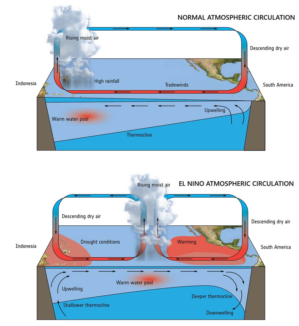
El Niño is the warm phase of the El Niño-Southern Oscillation (ENSO), a naturally occurring climate cycle in which sea surface temperatures in the equatorial Pacific Ocean fluctuate between warm (El Niño), cool (La Niña) and neutral phases every two to seven years. Although the phenomenon originates thousands of kilometres from Europe, it alters atmospheric circulation across the globe, influencing rainfall patterns, storm tracks and temperatures on every continent.
Scientists are increasingly concerned because current forecasts suggest this year's event could reach "Super El Niño" status — a rare category reserved for only the strongest warming episodes, including those of 1982-83, 1997-98 and 2015-16, all of which were associated with widespread weather disasters and record-breaking global temperatures.
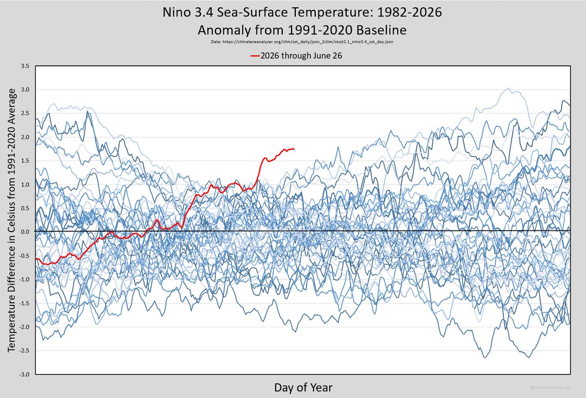
"The latest ocean analysis below shows a significant warm anomaly already emerging in the main ENSO regions," the report says. "This analysis is with the global average anomaly removed, so it shows the clean warm signal of the rising El Niño, creating a growing warm anomaly signature, expected to reach into the +4-5° anomalies at peak strength."
Those ocean temperatures are already beginning to reshape atmospheric circulation.
"A powerful Super El Niño is rapidly developing in the tropical Pacific, and the first clear atmospheric response is already showing up in the weather patterns," the report says. "Latest ocean and forecast data show the event strengthening toward rare intensity, with the atmospheric signal already visible in the analysis and forecast data."
June has already displayed weather patterns resembling previous Super El Niño years, particularly across North America.
Meteorologists note that North America typically experiences the first atmospheric impacts because of its proximity to the tropical Pacific, while Europe usually responds several months later in the autumn.
"This is reflected in the latest ENSO forecast from the NCEP CFSv2 model. It shows a very strong El Niño developing, exceeding the super El Niño threshold (+2°C above average), having an immediate impact on the summer, fall, and winter patterns. The current 2026 development shows a similar signature to the previous strongest events, forecast to rise even higher, as one of the strongest events on record."
One of the principal drivers behind the rapid intensification has been the development of a massive underwater pulse of warm water known as a Kelvin Wave.
"Strong westerly wind events have helped develop a massive underwater warm anomaly, called a Kelvin Wave. This wave rises from below, now visible as a warm anomaly on the ocean surface."
The warming ocean is already producing measurable changes in the atmosphere. According to the latest forecast from the European Centre for Medium-Range Weather Forecasts (ECMWF), rising air over the eastern Pacific and sinking air over the Indian Ocean are establishing what meteorologists describe as the “atmospheric bridge” linking tropical ocean temperatures with global weather systems that is typical in an El Niño year.
Historically, Super El Niños have contributed to flooding across parts of South America, droughts in Australia and Southeast Asia, disruptions to the Asian monsoon, increased wildfire risk and unusually warm winters across parts of North America.
Europe has yet to display the classic atmospheric signature associated with previous Super El Niño episodes, but forecasters say early indications are beginning to emerge.
Forecast models suggest northern and central Europe could increasingly come under the influence of persistent high-pressure systems later this summer, while lower-pressure systems develop farther south.
"Over Europe, we see a reversed pattern, with a strong blocking high-pressure anomaly over the northern and north-central parts, and a low-pressure anomaly undercut over the southern half. This is a Rex-block type pattern, while over North America, we see an Omega blocking trend," Severe Weather Europe reports.
Europe has just been through an “omega block” that trapped a “heatcap” over France and the rest of northern Europe leading to sweltering temperatures. And meteorologists are warning of a second omega block developing in the first half of July that may be even hotter and more persistent.
Follow us online