
The super El Nino is here

The planet’s seas are on their way to being as warm as bath water as the predicted super El Niño arrives. It is already clear that this year’s oceanic heating event will be the most powerful on record.
Global sea temperatures have already climbed past their previous all-time high, smashing records on their way, and forecasters warn that this year's El Niño could bring devastating extreme weather events.
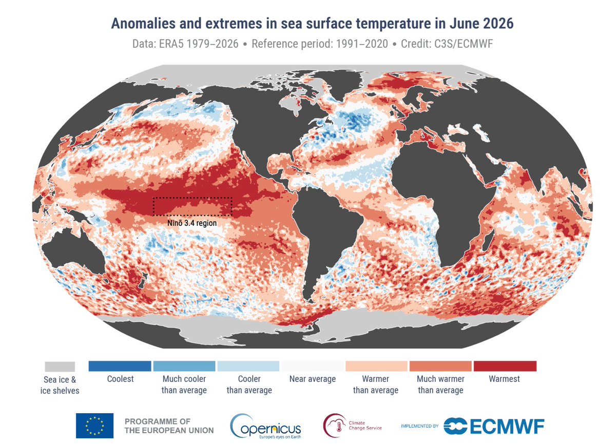
The seas are running a fever. June was the hottest on record for the world's oceans as well as the land, according to Copernicus. Nearly 40% of ocean area worldwide is in the midst of a marine heatwave, with intense hot patches in the Mediterranean Sea and the Pacific Ocean more than 10°C hotter than usual. It's the latest in a wave of ocean warming that began in 2023.
Oceans absorb more than 90% of the excess heat trapped by the greenhouse gases released when fossil fuels are burnt. Waters at the surface also exchange heat and moisture with the atmosphere, helping to drive hotter temperatures and more extreme weather. For every one degree Celsius of warming, the atmosphere can hold about 7% more moisture. It also holds onto the water for longer. That means more time between rainfall, and heavier, more dangerous deluges when rain does fall.
A recent study found that at least a fifth of heatwaves on land begin in the ocean. Last year, more people died from extreme heat than from road crashes in Europe, according to the World Resources Institute.
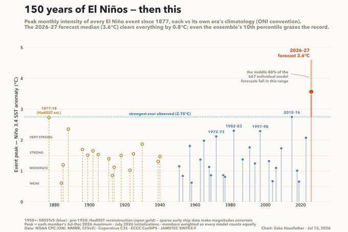
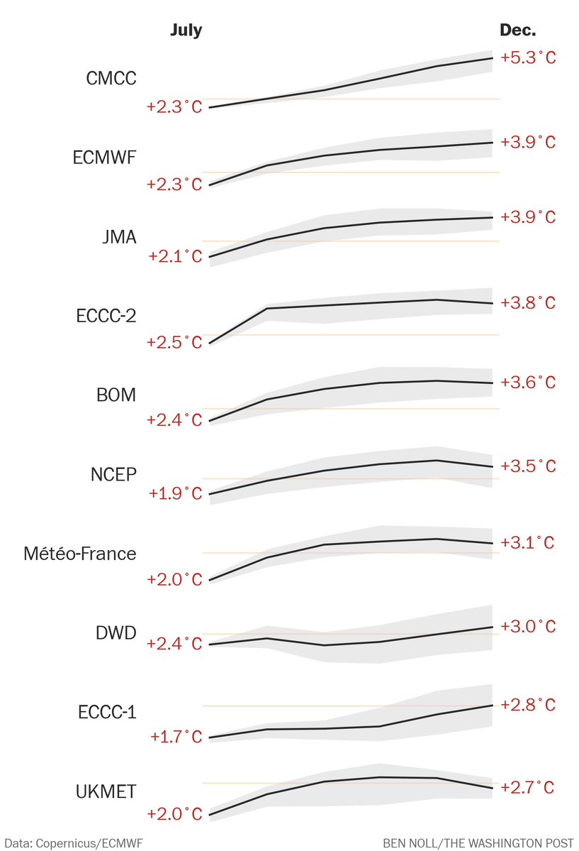
Scientists have been warning of a super charged El Niño that will go into full swing as the summer ends, but nine of ten forecast models are already describing a “strong-to-historic” event. The single most likely outcome by late 2026 is a "very strong" El Niño — the top tier of the scale, reserved for the handful of events since the 1950s in which the central Pacific warms by more than 2°C above normal.
El Niño is the warm phase of a natural climate cycle, the El Niño–Southern Oscillation (ENSO), driven by temperature swings in the central and eastern Pacific. It recurs roughly every two to seven years, typically emerges during the northern autumn, and can persist into the following year.
In general, El Niño years are associated with heavier rainfall in places like California and South America and drier conditions across Australia and Southeast Asia. And although El Niño tends to suppress hurricanes near the United States, other regions tend to see stronger cyclones with more rainfall.
This year the impact is expected to peak from late 2026 into 2027, as what scientists often call Earth's most important "control knob" for year-to-year climate variability is turned up to the maximum setting on record. On a scale of one to ten, it’s going to be an eleven.
NOAA's Climate Prediction Center, which moved to an El Niño Advisory on June 11, puts the probability of the event reaching "very strong" intensity by the November–January peak at around 63%, with a near-certain chance that some form of El Niño persists through the northern winter. Ocean temperatures are already at record levels, Europe has endured a record-breaking heatwave, and marine heatwaves have flared across the western Mediterranean and the Atlantic seaboard.
During El Niño, above-average water temperatures in the central and eastern Pacific shift the position and strength of the subtropical jet stream, with effects that reach into the Caribbean and the Atlantic. Because the phenomenon concentrates its deepest pool of warm water — and its lowest wind shear — across that basin, it turns the Pacific into a hyper-fuelled engine for major hurricanes and powerful typhoons. Tellingly, Taiwan, China and Vietnam are all already being battered this weekend by Typhoon Bavi, forecast to be among the most powerful storms to ever strike Asia.
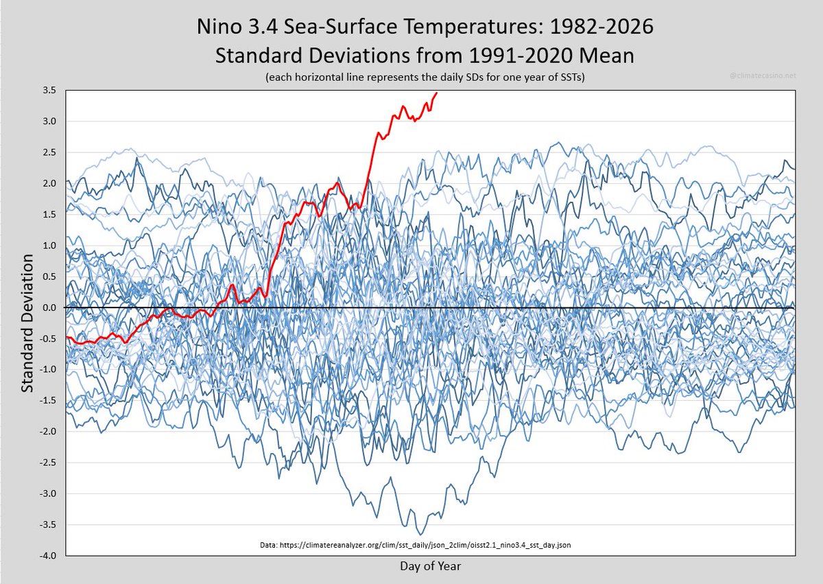
The numbers are already extreme. As of early July, the Niño-region sea-surface temperature anomaly had crossed 1.8°C above the 1991–2020 average — more than three standard deviations above the mean. In statistical terms, anything beyond two standard deviations is treated as an extreme aberration; this is, quite literally, an off-the-chart event.
Desperate measures
El Niño Is not going to smash previous records, scientists say it will break them by a huge margin. Some are starting to suggest desperate measures.
"With all the July model runs now in, it is very likely that 2026 will see the largest El Niño event since records began in the late 1800s – and potentially by a truly mind-blowing margin. The median estimate is now 3.6C, roughly 0.8C hotter than the prior record (2.75C)," climatologist Zeke Hausfather said in a newsletter post.
The proposal involves spraying microscopic sea salt particles into low-lying clouds over the Pacific Ocean. The salt particles would make the clouds brighter, allowing them to reflect more sunlight back into space. By reducing the amount of solar energy reaching the ocean's surface, researchers believe the technique could cool Pacific waters enough to reduce the strength of a developing Super El Niño.
Computer simulations suggest that, under the right conditions, the approach could cut the intensity of a Super El Niño by as much as 40%.
However, scientists stress that the idea remains purely theoretical and is not being recommended for real-world deployment. The Earth's climate system is extraordinarily complex, and no one fully understands the long-term consequences of deliberately altering cloud cover over the Pacific.
Even relatively small changes could disrupt the natural El Niño-La Niña cycle, with potentially far-reaching effects on global agriculture, rainfall patterns, heatwaves, floods, droughts and ultimately food and commodity prices.
For now, researchers see marine cloud brightening as an area for further study rather than an immediate climate solution. Nevertheless, the fact that geoengineering proposals are increasingly being discussed illustrates the growing concern among scientists over the scale of future climate risks and the possibility that conventional emissions reductions alone may not be sufficient to limit their impact.
Seas heating up
The clearest sign that something unusual is under way lies not in the tropics alone but in the oceans around the world. In June, the average sea-surface temperature for the extra-polar ocean — the vast band between 60°S and 60°N that excludes the ice-affected poles — was the highest ever recorded for the month, edging past the previous June record set in 2024 by 0.01°C, according to the Copernicus Climate Change Service.
That margin sounds trivial, but it matters for two reasons. First, it is a global average across an enormous area, so shifting it even a hundredth of a degree requires a colossal amount of additional heat spread across tens of millions of square kilometres of sea. Second, it comes on top of 2024's record, which was itself an outlier — meaning the ocean is not merely warm but setting fresh highs from an already elevated baseline, with little sign of the "cooling-off" that would normally follow a record year.
The heat is not evenly spread. It pools in hotspots where the numbers become genuinely startling: parts of the Mediterranean, the Gulf, and shallow tropical seas have pushed into the low 30s°C, temperatures at which coral bleaches, fish stocks flee or die, and the water gives up ever more moisture to feed storms. Marine heatwaves — prolonged spells of anomalously warm water — have become more frequent, more intense and longer-lasting worldwide, and this year's have struck close to home for Europe, scorching the western Mediterranean and reaching up the Atlantic coasts.
Those warm waters cause their own related damage. An unusually hot Mediterranean fuelled Storm Daniel in September 2023, a rare subtropical storm that ripped through Libya leaving more than 2,000 dead in its wake as a precursor to what this year’s super El Niño could cause.
Two forces are stacking up this year. One is El Niño itself, a natural redistribution of heat that temporarily warms the surface Pacific and nudges up the global average. The other is the long-term, human-driven warming trend on which El Niño now rides. The oceans have absorbed the overwhelming majority of the extra heat trapped by greenhouse gases — well over 90% — and each El Niño therefore breaks records from a higher starting line than the last. The result is a temporary but significant boost to global mean surface temperature layered on top of a rising floor: El Niño supplies the spike, climate change supplies the staircase.
The practical upshot is that the coming twelve months are likely to be exceptionally bad. This year's disaster season is likely to be worse than last year’s with a new batch of global temperature records, heightened risks of drought, flooding, coral bleaching and intense tropical cyclones running into 2027.
Heatwaves plague Europe
June 2026 was the hottest June recorded for western Europe and the second warmest globally, driven by the highest sea surface temperatures (SSTs) on record for the month, according to the monthly update from the Copernicus Climate Change Service (C3S), implemented by the European Centre for Medium-Range Weather Forecasts (ECMWF).
Europe also saw widespread dryness that, together with extreme heat, contributed to wildfire activity, particularly in the Iberian Peninsula and southern France, and heightened drought risk in parts of eastern Europe. The June heatwave occurred against a backdrop of increasingly dry soils across western and central Europe, further exacerbating drought conditions that had begun to develop during May's heatwave.
Globally June 2026 was the second-warmest in the ERA5 dataset, with an average surface air temperature of 16.54°C, 0.56°C above the 1991-2020 average for the month, behind June 2024.
The average temperature over European land in June 2026 was the second-highest on record for the month. Western Europe, the region most affected by the heatwave, experienced its warmest June on record, with an average temperature of 20.74°C, 3.05°C above the 1991–2020 average for June, surpassing the previous record set in June 2025.
The heat in parts of Western Europe is continuing in July, fuelling devastating wildfires in France and the Iberian Peninsula. Last year saw wildfires in Europe pass 1mn hectares for the first time. This year is likely to be worse.
Spain’s Fabra Observatory in Barcelona - one of WMO’s long-term weather observing stations - recorded 40.5°C on July 8 - the highest temperature in more than one century of data. France had a widespread amber alert (the second highest level) for heat as well as a high fire danger level because of drought, high temperatures and low humidity, according to Meteo-France.
WMO, its members and partners are mobilizing with early warnings and coordinated heat-health action plans to try to save lives and inform decision-making on how to minimise economic and ecosystem damage and disruption to infrastructure and labour productivity. It is accompanied by localized violent storms and in some areas by worsening drought and the risk of wildfires.
Extreme heat is expected to occur at increasing frequency and intensity and duration, according to the Intergovernmental Panel on Climate Change.
“Heatwaves like this are what we expect to see in a changing climate,” said John Kennedy, head of climate information at WMO. “In the 50 years since the historic heatwave in 1976, Europe as a whole has warmed by around two degrees. It’s the fastest warming continent and extremes of temperature have increased too,” he said.
Follow us online